Items related to Columbia River Gorge National Scenic Area Map (National...

� Waterproof � Tear-Resistant � Topographic Map
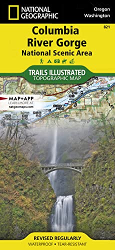
The magnificent Multnomah Falls is just one of many natural, cultural, and recreational attractions in the Columbia River Gorge Scenic Area. The 80-mile-long gorge contains diverse ecosystems ranging from the lush Oneonta Gorge Rain Forest to the arid Celilo Grasslands. Expertly researched and created in partnership with local land management agencies, National Geographic's Trails Illustrated map of Columbia River Gorge provides an unparalleled tool for exploring this breathtaking region. Some of the key areas of interest featured on the map include the White Salmon, Klickitat, Sandy, and Lower Deschutes rivers; Yacolt Burn State Forest; Maryhill, Columbia Hills, and Rooster Rock state parks; Mark O. Hatfield Wilderness; and portions of Mount Hood and Gifford-Pinchot national forests.
With miles of clearly marked trails including the Pacific Crest National Trail and the Oregon National Historic Trail, and such scenic roadways as the Historic Columbia River Highway and Yakima Scenic Byway, this map will prove invaluable whether you're taking in the scenery on foot or by car. A helpful list of waterfalls makes it easy to take in these natural wonders in your travels. Many recreation features are noted as well, including campgrounds, trailheads, interpretive trails, boat launches, and areas for fishing, windsurfing, and swimming. The map base includes contour lines and elevations for summits.
Every Trails Illustrated map is printed on "Backcountry Tough" waterproof, tear-resistant paper. A full UTM grid is printed on the map to aid with GPS navigation.
Other features found on this map include: Bonneville Dam, Bull Run Reservoir Number One, Camas, Columbia Hills, Deschutes River, Gifford Pinchot National Forest, Gresham, Hood River, Klickitat River, Lake Celilo, Mark O. Hatfield Wilderness, Mount Defiance, Mt. Hood National Forest, Multnomah Falls, Shellrock Mountain, The Dalles, Troutdale, Washougal, White Salmon River.
- Map Scale = 1:75,000
- Sheet Size = 37.75" x 25.5"
- Folded Size = 4.25" x 9.25"
"synopsis" may belong to another edition of this title.
About the Author:
Founded in 1915 as the Cartographic Group, the first division of National Geographic, National Geographic Maps has been responsible for illustrating the world around us through the art and science of mapmaking.Today, National Geographic Maps continues this mission by creating the world's best wall maps, recreation maps, atlases, and globes which inspire people to care about and explore their world.
"About this title" may belong to another edition of this title.
- PublisherNational Geographic Maps
- Publication date2023
- ISBN 10 1566954738
- ISBN 13 9781566954730
- BindingMap
- Number of pages2
Buy New
Learn more about this copy
US$ 19.43
Shipping:
FREE
Within U.S.A.
Top Search Results from the AbeBooks Marketplace
Stock Image
Columbia River Gorge National Scenic Area (Trails Illustrated Map #821) (National Geographic Maps: Trails Illustrated)
Published by
Natl Geographic Society Maps
(2009)
ISBN 10: 1566954738
ISBN 13: 9781566954730
New
Quantity: 1
Seller:
Rating
Book Description Map. Condition: New. Seller Inventory # DADAX1566954738
Buy New
US$ 19.43
Convert currency
Stock Image
Columbia River Gorge National Scenic Area (Folded)
Published by
National Geographic Maps, Evergreen
(2009)
ISBN 10: 1566954738
ISBN 13: 9781566954730
New
Quantity: 1
Seller:
Rating
Book Description Folded. Condition: new. Folded. National Geographic's Trails Illustrated Maps are the most detailed and up-to-date topographic recreation maps available for US National Parks, National Forests and other popular outdoor recreation areas. A necessity for exploring the outdoors, each map is printed on waterproof, tear-resistant material. They also contain key safety and contact information, GPS and compass coordinates, Leave No Trace ethical guidelines and hundreds of points-of-interest, including scenic viewpoints, campgrounds, boat launches, swimming areas, marine sanctuaries and wildlife refuges. Shipping may be from multiple locations in the US or from the UK, depending on stock availability. Seller Inventory # 9781566954730
Buy New
US$ 23.21
Convert currency
Stock Image
Columbia River Gorge, Columbia River Gorge National Scenic Area Trails Illustrated Other Rec Areas National Geographic Trails Illustrated Map
Published by
National Geographic Maps
(2012)
ISBN 10: 1566954738
ISBN 13: 9781566954730
New
Quantity: 7
Seller:
Rating
Book Description UNK. Condition: New. New Book. Shipped from UK. Established seller since 2000. Seller Inventory # EA-9781566954730
Buy New
US$ 23.71
Convert currency
Stock Image
Columbia River Gorge, Columbia River Gorge National Scenic Area
Published by
National Geographic Maps Division 2012-08-02, Washington, D.C.
(2012)
ISBN 10: 1566954738
ISBN 13: 9781566954730
New
Quantity: 1
Seller:
Rating
Book Description sheet map (folded). Condition: New. Language: ENG. Seller Inventory # 9781566954730
Buy New
US$ 19.78
Convert currency
Stock Image
National Geographic Trails Illustrated Map Columbia River Gorge, Columbia River Gorge National Scenic Area Oregon / Washington, USA
Seller:
Rating
Book Description Map. Condition: Brand New. map edition. 2 pages. 0.25x9.25x4.25 inches. In Stock. Seller Inventory # __1566954738
Buy New
US$ 17.14
Convert currency
Stock Image
National Geographic Trails Illustrated Map Columbia River Gorge, Columbia River Gorge National Scenic Area Oregon / Washington, USA
Seller:
Rating
Book Description Map. Condition: Brand New. map edition. 2 pages. 0.25x9.25x4.25 inches. In Stock. Seller Inventory # 1566954738
Buy New
US$ 32.86
Convert currency
Stock Image
Columbia River Gorge National Scenic Area Map (National Geographic Trails Illustrated Map, 821)
Published by
National Geographic Maps
(2023)
ISBN 10: 1566954738
ISBN 13: 9781566954730
New
Paperback
Quantity: 1
Seller:
Rating
Book Description Paperback. Condition: new. Brand New Copy. Seller Inventory # BBB_new1566954738
Buy New
US$ 47.76
Convert currency
Stock Image
Columbia River Gorge National Scenic Area Map (National Geographic Trails Illustrated Map, 821)
Published by
Natl Geographic Society Maps
(2023)
ISBN 10: 1566954738
ISBN 13: 9781566954730
New
Quantity: 1
Seller:
Rating
Book Description Condition: new. Seller Inventory # FrontCover1566954738
Buy New
US$ 46.50
Convert currency
Stock Image
Columbia River Gorge National Scenic Area Map (National Geographic Trails Illustrated Map, 821)
Published by
National Geographic Maps
(2023)
ISBN 10: 1566954738
ISBN 13: 9781566954730
New
Paperback
Quantity: 1
Seller:
Rating
Book Description Paperback. Condition: new. New. Seller Inventory # Wizard1566954738
Buy New
US$ 47.31
Convert currency
Stock Image
Columbia River Gorge National Scenic Area Map (National Geographic Trails Illustrated Map, 821)
Published by
National Geographic Maps
(2023)
ISBN 10: 1566954738
ISBN 13: 9781566954730
New
Paperback
Quantity: 1
Seller:
Rating
Book Description Paperback. Condition: new. Buy for Great customer experience. Seller Inventory # GoldenDragon1566954738
Buy New
US$ 47.67
Convert currency